BRIEF PREHISTORY OF PROJECT
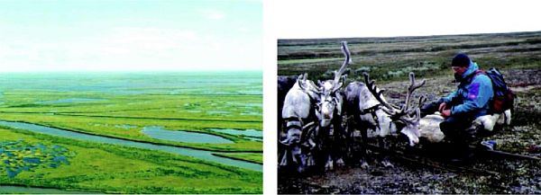
With a length of 1,809 km, the Pechora river is the largest European river draining into the Arctic Ocean. The Pechora basin extends over a total area of 322,000 km2 covering a considerable part of the Timan mountain range, the Pechora lowland depression plain, the western slopes of the Northern, Subarctic and Arctic Urals and the tundra zone. The Pechora river basin includes more than 31,500 tributaries of the 1st to 4th order as well as 62,140 lakes with an overall surface area exceeding 4,000 km2.
Before draining into the Pechora Bay, the river forms a delta with surface area of about 15,000 km2. To the West and East the delta is bordered by upland tundra ecosystems, while a coastal lowland plain extends to the North-West. The almost total absence of industry, the insignificant role of agriculture, the lack of infrastructure and the non-regulated discharge of the Pechora river make it possible to use the region as a amenable model for studying the structural-functional organization of natural terrestrial and aquatic ecosystems, as well as the processes related to the temporal and spatial distribution of flora & fauna diversity.
DATES OF IMPLEMENTATION OF PROJECT
1995-1999
FUNDING ORGANIZATIONS
RIZA, Institute for Inland Water Management & Waste Water Treatment, Directorate-General for Public Works & Water Management, Ministry of Transport, Public Works & Water Management, the Netherlands Institute of Biology, Komi Science Centre, Ural Division, Russian Academy of Sciences, Russia
PROJECT CO-ORDINATOR
Dr. M.R. van Eerden, RWS RIZA, Lelystad, the Netherlands
RESPONSIBLE SCIENTISTS
Dr. A.I. Taskaev, Dr. I.A. Lavrinenko, Dr. V.I. Ponomarev


